Flash Flood, Tornado Warnings Hit Southwest Missouri Communities
Severe storms dump up to 4 inches of rain across southwest Missouri, triggering flash flood warnings and tornado watches affecting dozens of communities.
LAMAR, MISSOURI — Severe thunderstorms brought dangerous flash flooding and tornado threats to communities across southwest Missouri and southeast Kansas Tuesday evening, prompting multiple weather warnings that lasted into early Wednesday morning.
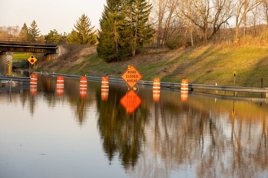
The National Weather Service in Springfield issued flash flood warnings for multiple areas after thunderstorms dumped 2 to 4 inches of rain across the region. Emergency management officials reported ongoing flooding as of 10:18 p.m. Tuesday, with additional rainfall expected to worsen conditions.
Multiple Communities Under Flash Flood Warnings
The warnings affected numerous communities including Lamar, Columbus, Carl Junction, Oronogo, Jasper, Golden City, Alba, Scammon, Purcell, Nashville, Carytown, Asbury, Neck City, Lamar Heights, Waco, Opolis, Lawton, Oakton, Boston, Crestline, Kenoma, Skidmore, Stippville and Neutral. Flash flooding threatened small creeks and streams, urban areas, highways, streets and underpasses, as well as other poor drainage and low-lying areas.
Specific low water crossings at risk included Dry Fork at Pine Road and Muddy Creek at Highway 126, according to the National Weather Service warnings.
Tornado Watch Extended Across Region
A tornado watch remained in effect until midnight Wednesday for parts of Kansas and Missouri. The watch covered two counties in southeast Kansas — Cherokee and Crawford — and eight counties in southwest Missouri including Barton, Cedar, Dade, Greene, Jasper, Lawrence, Newton and Polk.
Cities under the tornado watch included Arnica, Aurora, Baxter Springs, Bolivar, Caplinger Mills, Carthage, Cedar Springs, Chicopee, Columbus, El Dorado Springs, Filley, Greenfield, Joplin, Kenoma, Lamar, Lockwood, Lone Oak, Lowell, Marionville, Meinert, Mount Vernon, Neosho, Neutral, Pittsburg, Riverton, Sherwin, Springfield, Stippville and Stockton.
Severe Storm Warnings Earlier Tuesday
The dangerous weather began earlier Tuesday evening when the National Weather Service issued a severe thunderstorm warning for eastern Cherokee County in Kansas and portions of Barton, Newton and Jasper counties in Missouri until 7:15 p.m.
At 6:07 p.m., radar indicated a severe thunderstorm near Carl Junction, about 7 miles northwest of Joplin, moving east at 35 mph with 60 mph wind gusts and quarter-size hail. The storm threatened locations including Joplin, Carthage, Webb City, Carl Junction, Lamar, Baxter Springs, Columbus, Galena, Oronogo, Carterville, Duquesne, Sarcoxie, Duenweg, Jasper, Golden City, Airport Drive, Leawood, Lowell, Silver Creek and Alba.
Interstate 44 between mile markers 5 and 32 was included in the severe thunderstorm warning area. The National Weather Service warned residents to expect hail damage to vehicles and wind damage to roofs, siding and trees.
Flash flood warnings remained in effect until 11:45 p.m. Tuesday for the hardest-hit areas, with radar showing between 1 and 3 inches of rain had already fallen by early evening, with additional rainfall amounts up to 2 inches possible in some areas.