Missouri Rivers Face Moderate Flooding as Heavy Rains Trigger Statewide Warnings
Rivers across Missouri surge toward moderate flooding as heavy rains trigger multiple warnings through Wednesday, with highways and roads facing potential closure.
BOONVILLE, MISSOURI — Multiple rivers across Missouri are experiencing moderate to minor flooding due to heavy rainfall, with the National Weather Service issuing flood warnings for waterways in Cooper, Jackson, Ray, Lafayette, and Osage counties through Wednesday.
The Petite Saline Creek near Boonville is forecast to reach moderate flooding levels, cresting at 19.7 feet just after midnight Monday into Tuesday. At 10:30 AM Monday, the creek stood at 14.5 feet, with flood stage beginning at 16.0 feet, according to the National Weather Service Kansas City/Pleasant Hill office.
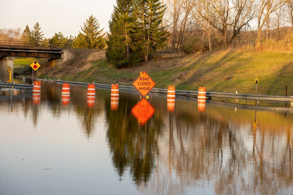
“At 19.5 feet, the creek floods U Highway about 4 miles southeast of Boonville,” the weather service warned in its flood advisory issued at 11:21 AM Monday.
Lamine River Approaching Critical Levels
The Lamine River near Otterville in Cooper County is also forecast to experience moderate flooding, expected to crest at 19.4 feet just after midnight. The river measured 10.9 feet at 10:15 AM Monday, below its 15.0-foot flood stage but rising rapidly.
Officials warn that at 18.0 feet, some gravel roads upstream and downstream from Otterville will be underwater, and State Highway 135 may be overtopped by floodwaters 2 miles north of Clifton City.
Missouri River and Flash Flood Concerns
The Missouri River at Napoleon, affecting Jackson, Ray and Lafayette counties, is forecast to reach minor flooding at 17.1 feet Tuesday morning. The river stood at 8.6 feet at 9:00 AM Monday, well below the 17.0-foot flood stage.
Flash flooding has already begun in portions of southeastern Iowa and west-central Illinois, with trained weather spotters reporting flooding in Keokuk, Iowa and Hamilton, Illinois. Between 1 and 2 inches of rain have fallen in the warned areas, with an additional inch possible.
The Maries River near Westphalia reached 10.1 feet Monday morning, slightly above its 10.0-foot flood stage, and is expected to crest at 10.2 feet Monday afternoon before falling below flood stage.
A broader flash flood watch remains in effect until 9:00 PM Monday for portions of Missouri and Illinois, including Boone, Callaway, Cole, Franklin, Gasconade, Jefferson, Lincoln, Moniteau, Montgomery, Osage, Pike, Saint Charles, Saint Louis City, Saint Louis, and Warren counties in Missouri.
The National Weather Service advises residents in affected areas to avoid driving through flooded roadways and to monitor local conditions closely as river levels continue to rise throughout Monday evening.